
Voyis VSLAM Powered by EIVA NaviSuite: Redefining Underwater Navigation
Accuracy in navigation and mapping has always been an issue in the underwater world—particularly when one can’t see clearly or doesn’t have GPS. Enter Voyis VSLAM enabled by EIVA NaviSuite. This robust combination is revolutionizing how subsea operations are performed by providing real-time, high-resolution navigation, 3D mapping, and upgraded situational awareness.
Whether you’re involved in offshore energy, underwater research, or marine construction, this technology can significantly boost the accuracy and efficiency of your operations.
What Is Voyis VSLAM?
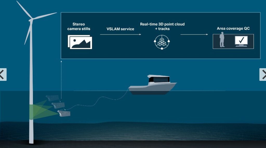
Voyis VSLAM (Visual Simultaneous Localization and Mapping) is a cutting-edge system that uses optical imaging and advanced algorithms to help underwater vehicles—like ROVs (Remotely Operated Vehicles) and AUVs (Autonomous Underwater Vehicles)—navigate and map complex environments in real time.
In contrast to most traditional navigation gear, which relies to a great extent on inertial systems or sound positioning, Voyis VSLAM uses high-definition cameras and computer vision to track movement and create maps in tandem. This allows for precise navigation when GPS signals are not accessible, such as in deep-sea environments or restricted underwater zones.
EIVA NaviSuite: The Software Backbone
EIVA NaviSuite is a high-performance software platform widely used in the marine industry for navigation, data acquisition, and real-time processing. It supports a very long list of subsea sensors like sonar, LiDAR, and now—even thanks to this collaboration—visual navigation through Voyis VSLAM.
Thanks to the integration of Voyis’ leading VSLAM technology with NaviSuite’s intuitive software tools, users can now benefit from smooth integration of navigation data, 3D mapping, and mission planning—within one interface.
Key Benefits of Voyis VSLAM with NaviSuite
1. Live 3D Mapping
Voyis VSLAM generates a live 3D map of the surroundings at all times. This is particularly useful in difficult underwater terrain, such as shipwrecks, pipelines, or coral reefs. Operators are provided with instant visual cues, allowing quick decision-making and precise maneuvering.
2. Localization Without GPS
Since GPS does not work underwater, most subsea vehicles employ DVLs (Doppler Velocity Logs), USBLs (Ultra Short Baseline), or inertial systems, which are expensive and require frequent calibration. Voyis VSLAM, on the other hand, employs visual cues from cameras to track movement, a more dynamic and reliable solution.
3. Smart Integration with NaviSuite
Because it is integrated with EIVA NaviSuite, the system can integrate visual navigation data with other sources such as sonar, LiDAR, and motion sensors. This allows for multi-sensor fusion, further ensuring the accuracy and reliability of navigation and mapping.
4. Improved Mission Efficiency
Operators are able to plan, monitor, and edit missions more effectively through real-time mapping and navigation data. This reduces underwater time and minimizes errors or missing data.
5. Post-Mission Analysis and Reporting
All data collected during the mission, including imagery, position, and 3D models, can be analyzed and processed in NaviSuite following the mission. This streamlines post-processing, inspection reporting, and asset management.
Applications Across Marine Industries
Voyis VSLAM with EIVA NaviSuite is not just a technological novelty—it’s a productive tool for many industries:
Offshore Oil & Gas: Enables accurate inspection of subsea assets like pipelines, manifolds, and risers.
Marine Construction: Allows real-time site monitoring and progress reporting.
Environmental Surveys: Ideal for mapping coral reefs, marine habitat surveys, and biodiversity measurement.
Wreck Exploration & Archaeology: Delivers accurate reconstructions of wreck sites and ancient buildings.
Defense & Security: Enhances situational awareness on surveillance or mine countermeasure operations.
Why This Integration Matters
The coupling of Voyis VSLAM and EIVA NaviSuite is a major milestone in underwater autonomy and navigation. It removes the dependency on traditional acoustic systems and offers a cost-effective, camera-based option that works in real time.
For those organizations seeking to improve the reliability, accuracy, and productivity of underwater operations, this hybrid solution offers a compelling value proposition.
System Requirements & Compatibility
Compatible with most ROVs and AUVs using high-resolution sensors
Compliant with existing NaviSuite workflows and sensor configurations
Compatible with other positioning systems to provide hybrid navigation
Final Thoughts
Subsea operations are complicated, but with technology such as Voyis VSLAM powered by EIVA NaviSuite, they’re getting smarter, faster, and more accurate. This convergence is a game-changer for marine experts who require precise, real-time data in situations where conventional technology doesn’t deliver.
If your job includes subsea navigation, surveying, or inspection, an investment in this next-generation technology might be a giant leap forward.
Comments are closed.